Unstable Weather Hits End of May, Sea Lovers Urged to Take Care
The Meteorological Department’s estimates at the Directorate General of Civil Aviation forecast that Lebanon will be affected by mild spring weather with some local fluctuations due to the influx of relatively cold air masses into the eastern Mediterranean region.
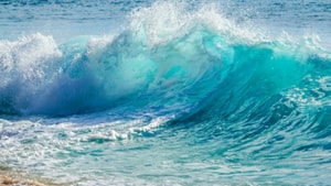
It also warns of rising sea waves and the formation of strong currents on Friday and Saturday, especially along the northern coasts.
Expected weather in Lebanon:
Wednesday: Partly cloudy to mostly cloudy with fog over mid-altitudes. Temperatures remain largely unchanged on the coast, while rising significantly in the mountains and inland, exceeding seasonal averages, then gradually decreasing from the afternoon over northern mountains, with conditions becoming favorable for light scattered rainfall at times.
Thursday: Partly cloudy with local fog on the highlands. Slight temperature increase on the coast and a noticeable decrease in the mountains and inland, with occasional strong winds.
Friday: Partly cloudy to cloudy with a further drop in temperatures in the mountains and inland, falling below seasonal averages. Fog will form on the highlands and winds will strengthen, reaching up to 55 km/h, raising sea waves to around 2 meters in the north. Light scattered rain is expected, especially over southern mountains.
Saturday: Partly cloudy with fog on the highlands and a slight rise in temperatures. Light scattered rain is expected at times, particularly in inland areas from the afternoon onward.
Surface winds: Northwesterly to southwesterly, 10–30 km/h
Visibility: Good on the coast, occasionally poor over mid-altitudes due to fog
Relative humidity on the coast: 60–80%
Sea state: Moderate waves
Sea surface temperature: 21°C
Atmospheric pressure: 1015 hPa (761 mmHg)
Sunrise: 05:31
Sunset: 19:40